
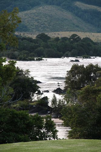
The Ecosystem and Relict Cultural Landscape of Lopé-Okanda demonstrates an unusual interface between dense and well-conserved tropical rainforest and relict savannah environments with a great diversity of species, including endangered large mammals, and habitats. The site illustrates ecological and biological processes in terms of species and habitat adaptation to post-glacial climatic changes. It contains evidence of the successive passages of different peoples who have left extensive and comparatively well-preserved remains of habitation around hilltops, caves and shelters, evidence of iron-working and a remarkable collection of some 1,800 petroglyphs (rock carvings). The property’s collection of Neolithic and Iron Age sites, together with the rock art found there, reflects a major migration route of Bantu and other peoples from West Africa along the River Ogooué valley to the north of the dense evergreen Congo forests and to central east and southern Africa, that has shaped the development of the whole of sub-Saharan Africa.
The Ecosystem and Relic Cultural Landscape of Lopé-Okanda represents an unusual interface between dense and well conserved tropical rainforest and relict savannah environments. A greater number of threatened species of large mammals find their last refuge in Lopé-Okanda than in any other comparable rainforest area in the Congo Rainforest Biogeographical Province
The Lopé-Okanda National Park Southern Africa , in the Neolithic and Iron Age, as evidenced in extraordinary number of substantial settlements sites and an extensive collection of rock art petroglyphs.
The Lopé-Okanda National Park provides the oldest dates for the extension of the Tshitolien culture towards the Atlantic and it has revealed evidence of the early domestication of plants and animals and the use of forest resources.
Criterion (iii): the rich archaeological ensembles of the middle stretches of the River Ogooué Valley
Criterion (iv): the collection of Neolithic and Iron Age sites together with the rock art remains appear to reflect a major migration route of Bantu and other peoples along the River Ogooué valley to the north of the dense evergreen Congo forests from West Africa to central east and southern Africa, that has shaped the development of the whole of sub-Saharan Africa. The subsidiary Iron Age sites within the forest provide evidence for the development of forest communities and their relationship with present day peoples.
Criterion (ix): The nominated property demonstrates an unusual interface between forest and savannah environments, and a very important manifestation of evolutionary processes in terms of species and habitat adaptation to post-glacial climatic changes. The diversity of species and habitats present are the result of natural processes and also the long-term interaction between man and nature.
Criterion (x): The diversity of habitats and the complex relationship between forest and savannah ecosystems have contributed to a high biological diversity particularly in relation to the property's flora, making it one of the most outstanding areas in relation to floristic diversity and complexity in the Congo Rainforest Biogeographical Province Gabon
The property is of sufficient size to maintain the long-term ecological viability of its habitats and ecosystems. The conservation and management of the property is guided by a management plan for the period 2006-2011 which is supported by international cooperation, particularly through a number of international and national NGOs. Conservation and management of the property also benefits from a number of transboundary cooperation initiatives. Key management issues include the need to resolve conflicts from competing interests, and to raise awareness amongst local people on the importance of conserving this property and to involve them in its management. Control and regulation of commercial poaching is of priority as well as the need to fully enforce regulations banning commercial logging within the property. Additional financial, logistical and human resources need to be obtained to ensure the effective management of the property and its buffer zone.
The authenticity of the archaeological sites and rock art site is intact. There is a need for consolidation of the excavated sites to be carried out to ensure that they are not eroded by natural or human processes.
The integrity of the cultural sites lies mainly in their relationship to one another along the River Ogooué Valley
The legal protective measures for the property are adequate to protect the cultural attributes of the landscape. Without a mission to the main archaeological sites in the River Ogooué Valley
Le début de l'histoire du site a été amplement évoqué précédemment.
Les fouilles archéologiques de la zone ont commencé en 1987 et se poursuivent aujourd'hui.
Dans la ceinture de savane, qui a attiré des populations en grand nombre sur plusieurs millénaires, des gens vivent encore aujourd'hui. Les langues parlées dans la zone sont organisées en plusieurs groupes, parmi lesquels : Okandais, Simba et Pouvi, Makina, Akélé, Mbahouin, Saké et Massango.
Aux XIXe et XXe siècles, avec l'arrivée du régime colonial, les peuplements, alors formés de petits hameaux pour chaque famille, ont été regroupés en villages et villes plus grands. En 1967, la Route nationale 3 fut construite le long de la vallée pour faciliter l'exploitation des forêts. Les principaux villages se trouvent aujourd'hui le long de cette route.
En 1976, un chemin de fer a été construit par un consortium, Eurotrag, entre Libreville, sur la côte, et Franceville, dans la forêt. Ce chemin de fer devait faciliter l'exploitation du manganèse et du bois. Cela conduisit à la création de nouveaux villages autour des gares d'Ayem et de Lopé.
Aujourd'hui, environ 2 000 personnes vivent à l'intérieur des limites de la zone proposée pour inscription, dans six petits villages. Trois le long de la vallée de l'Ogooué : Boléko (Lopé), Kongoboumba et Kazamabika, et trois dans le sud, le long de l'Offoué : Makoghé, Badondé et Mikongo, auxquels on ajoutera les deux villages de Ramba et de Massenguelani, où vivent des populations bantoues et pygmées. Les six principaux villages sont désignés comme zones de développement, pour encourager l'essor des marchés de produits locaux et de l'écotourisme.
Dans la zone tampon se trouve Aschouka. Un campement touristique a été installé à Lopé, la station de Boleko.
Lopé-Okanda a été classé comme réserve en 1946, et, en 2002, est devenu parc national.


Niciun comentariu:
Trimiteți un comentariu